Showing posts with label ~ UNESCO. Show all posts

Thursday, March 24, 2011

ES-84493 ESPANA / SPAIN - Anna (Al-Ḥamrā' الْحَمْرَاء‎)


~ Granada, Spain ~ (ES-84493)
Al-amrā' الْحَمْرَاء‎,
Thanks for Anna
Sent: 17th AUGUST 2010
Received: AUGUST 2010

The Alhambra , the complete form of which was Calat Alhambra (الْقَلْعَةُ ٱلْحَمْرَاءُ, Al-Qal‘at al-amrā’ , "the red fortress"), is a palace and fortress complex constructed during the mid 14th century by the Moorish rulers of the Emirate of Granada in Al-Andalus, occupying the top of the hill of the Assabica on the southeastern border of the city of Granada in the Autonomous Community of Andalusia.

The Alhambra's Moorish palaces were built for the last Muslim Emirs in Spain and its court, of the Nasrid dynasty. After the Reconquista (reconquest) by the Reyes Católicos ("Catholic Monarchs") in 1492, some portions were used by the Christian rulers. The Palace of Charles V, built by Charles V, Holy Roman Emperor in 1527, was inserted in the Alhambra within the Nasrid fortifications. After being allowed to fall into disrepair for centuries, the Alhambra was "discovered" in the 19th century by European scholars and travelers, with restorations commencing. It is now one of Spain's major tourist attractions, exhibiting the country's most significant and well known Islamic architecture, together with 16th-century and later Christian building and garden interventions. The Alhambra is a UNESCO World Heritage Site, and the inspiration for many songs and stories.


Saturday, March 19, 2011

2010 July, Arvind from भारत INDIA (लाल किला The Red Fort)

~ मेरठ भारत / MEERUT, India ~
धन्यवाद ARVIND KUMAR AGGARWAL
भेजा: 21st JULY 2010
प्राप्त: AUGUST 2010
Thanks for Arvind, inceasing again my UNESCO collection....


लाल किला The Red Fort usually transcribed into English as Lal Qil'ah or Lal Qila) is a 17th century fort complex constructed by the Mughal emperor Shah Jahan in the walled city of Old Delhi (in present day Delhi, India). It served as the capital of the Mughals until 1857, when Mughal emperor Bahadur Shah Zafar was exiled by the British Indian government. The British used it as a military camp until India became independent in 1947. It is now a popular tourist site, as well as a powerful symbol of India's sovereignty: the Prime Minister of India raises the flag of India on the ramparts of the Lahori Gate of the fort complex every year on Independence Day. It was designated a UNESCO World Heritage Site in 2007.

Mughal Emperor Shahjahan, started construction of the massive fort in 1638 and work was completed in 1648 (10 years). The Red Fort was originally referred to as "Qila-i-Mubarak" (the blessed fort), because it was the residence of the royal family. The layout of the Red Fort was organised to retain and integrate this site with the Salimgarh Fort. The fortress palace was an important focal point of the medieval city of Shahjahanabad. The planning and aesthetics of the Red Fort represent the zenith of Mughal creativity which prevailed during the reign of Emperor Shah Jahan. This Fort has had many developments added on after its construction by Emperor Shahjahan. The significant phases of development were under Aurangzeb and later Mughal rulers. Important physical changes were carried out in the overall settings of the site after the Indian Mutiny in 1857. After Independence, the site experienced a few changes in terms of addition/alteration to the structures. During the British period the Fort was mainly used as a cantonment and even after Independence, a significant part of the Fort remained under the control of the Indian Army until the year 2003. The Red Fort is an attraction for tourists from around the world.

The Red Fort was the palace for Mughal Emperor Shah Jahan's new capital, Shahjahanabad, the seventh city in the Delhi site. He moved his capital here from Agra in a move designed to bring prestige to his reign, and to provide ample opportunity to apply his ambitious building schemes and interests.

The fort lies along the Yamuna River, which fed the moats that surround most of the wall. The wall at its north-eastern corner is adjacent to an older fort, the Salimgarh Fort, a defence built by Islam Shah Suri in 1546.The construction of the Red Fort began in 1638 and was completed by 1648.
The Indian flag flying from Delhi Gate

On 11 March 1783, Sikhs briefly entered Red Fort in Delhi and occupied the Diwan-i-Am. The city was essentially surrendered by the Mughal wazir in cahoots with his Sikh Allies. This task was carried out under the command of Baba Jassa Singh Ahluwalia and Sardar Baghel Singh Dhaliwal, who led Karor Singhia misl which comprised Jat Sikhs from present day Amritsar and Tarn Taran districts (some major villages being Chabal, Naushehra Pannuan, Sirhali, Guruwali, Chabba, Sur Singh, Bhikhiwind, Khadur Sahib, Chola Sahib etc.) .

The last Mughal emperor to occupy the fort was Bahadur Shah II "Zafar". Despite being the seat of Mughal power and its defensive capabilities, the Red Fort was not defended during the 1857 uprising against the British. After the failure of the 1857 rebellion, Zafar left the fort on 17 September. He returned to Red Fort as a prisoner of the British. Zafar was tried on in a trial starting on 27 January 1858, and was exiled on 7 October.

Tuesday, March 8, 2011

LT-113425 LITHUANIA from Egle


~ Vilnius, Lithuania ~ (LT-113425)
This card was made a day for me... 

Thanks for Egle (Postcrossing ID: Spygyls)
http://www.postcrossing.com/user/Spyglys
Sent: 11th Feb. 2010
Received: Feb. 2010

HISTORY of TRAKAI Island Castle
When the Peninsular castle was being built, fortified and expanded - at the second half of the 14th century - the Island Castle was begun to be build on one larger island of Galve Lake. At the first stage of building works the Island Castle was of an in-between type – either fenced or conventional – it was of U form and had duke palace and ante palace. It is thoughts that Island Castle was begun by Kestutis and finished in the early 15th century by his son Vytautas. It was meant to be a fortress and it was never conquered by any raiders.

At the second stage of building works the layout of the castle was a little changed: between the two castle blocks a 9,2 x 9,6 m large and 6 floors height donjon was constructed (33 meters), and at the edge of the island a defensive wall with counterforts was built. The architecture style of the Castle is Gothic but separate elements were of Romanesque style. All the rooms were arced, window slots were decorated with trimmed bricked. On the second floor of the right block there was a representative chamber; windows were decorated with stained-glass. About the architecture of the Island and Peninsular Castles there was for the first time mentioned by a Fleming traveller Giliber de Launa, indicating that “the second Castle is in the middle of the lake in a distance of a cannon shoot form the first Castle. It is completely new and is built from brick according the French example.” At the last stage of the building works a fossa was pitched, separating duke castle from the ante-castle, it is hedged with a defensive wall with towers, there were casemates built. In the southern and triangular casemates there were kitchens, on the lower floors of the western casemates there were stockrooms, and on the second floor of casemates servants lived. In the southwest tower if the Castle there was a prison. The ante-castle gained a form of irregular trapezium, in the Eve of the Battle of Grunwald the Castle was expanded and renewed; the angle towers were readjusted for the flank defence and had 15 cannons. After the Battle of Grunwald (in 1410), having defeated the Teutonic Order the Island Castle became the residence of the Grand Duke. In the beginning of the 15th century Trakai was a flowering town, frequently visited by merchants, honoured guests, foreign messengers, who were welcomed in the representative chamber of the Island Castle. In 1413 in the Island Castle there was welcomed the Emperor Zigmantas’s messenger Benedict Macra, who was assigned an arbiter in the argument with the Order on the border with Samogitia. The Polish King Jogaila (Vytautas’s cousin) came with a visit for 13 times.

In the 16th century after having lost the military and residential functions the role of the Castle went down and the Grand Dukes visited it more and more seldom. The Metrics that was kept in the Castle was moved to Vilnius in 1511. The Island Castle becomes a prison for noble criminals.

After desolating invasion of the Tsarist Russia in 1655 – 1661 Trakai town was plundered and burned, the Island Castle was destroyed and was not rebuilt; the town never revived and became a province.

In the 19th century
Romanticism ideas lead to show interest in Lithuanian past, especially Trakai Castles. Artists painted the ruins of the Island Castle, the remained fragments of the frescoes, the engineers – architects prepared the restoration projects for the castle. Engineer B.Malevskis prepared a project for fragmentary and conservational works in the ante-castle west-east tower. Although the works accomplished were not large, in the history of castle preservation they were very important. In 1929 – 1941 the restoration works were supervised by a Polish architect J.Borovskis. In that period the sole of the stonework was consolidated, the corner counterforts were restored/renewed, the remains of the ruin were removed form the fa?ade, the donjon was fortified, the representative chamber was began to be reconstructed.

After the World War II the conservational, restoration and reconstructional works were continued by Lithuanian restaurateurs. In 1953 the reconstructional works of the Castle started. In 1962, following the project of architect B.Kruminis the central palace were rebuilt, and in 1987, following the architect St.Mikulionis the anti-castle was rebuilt. The corner towers of the anti-castle were also rebuilt and the western casemates transformed the whole volume/size of the dimensional composition of the Castle. The symbol of Lithuanian and of town Trakai – the Island Castle – regained its previous outlook as it was in the 15th century. After the re-establishment of Lithuanian Independence Trakai Island Castle again welcomes honoured Lithuanian guests; it also is a place where important contracts are signed.

In 1962 the Island Castle was conveyed to Trakai History Museum. Many expositions were installed since then, many exhibitions are now open to the visitors, and numerous exciting concerts, festivals and holiday events take place in the Island Castle in the present days.


2nd Phase

3rd Phase 

Trakai Island Castle in Ruins (1877)

Tuesday, February 22, 2011

2010-04-07 ROMANIA from Emil Levitchi


~ BUCHAREST, ROMANIA ~
Big size Castle card feels like go into Harry Potter world... I love it...

Cancellation on 7th April 2010

Thanks for EMIL LEVITCHI!!


Bran Castle (German: Törzburg; Hungarian: Törcsvár), situated near Bran and in the immediate vicinity of Braşov, is a national monument and landmark in Romania. The fortress is situated on the border between Transylvania and Wallachia, on DN73. Commonly known as "Dracula's Castle" (although it is one among several locations linked to the Dracula legend, including Poenari Castle and Hunyad Castle), it is marketed as the home of the titular character in Bram Stoker's Dracula. There is, however, no evidence that Stoker knew anything about this castle, which has only tangential associations with Vlad III, voivod of Wallachia, the putative inspiration for Dracula.

The castle is now a museum open to tourists, displaying art and furniture collected by Queen Marie. Tourists can see the interior individually or by a guided tour. At the bottom of the hill is a small open air museum park exhibiting traditional Romanian peasant structures (cottages, barns, etc.) from across the country.

History

In 1212, Teutonic Knights built the wooden castle of Dietrichstein as a fortified position in the Burzenland at the entrance to a mountain valley through which traders had travelled for more than a millennium, although it was destroyed in 1242 by the Mongols. The first documented mentioning of Bran Castle is the act issued by Louis I of Hungary on November 19, 1377, giving the Saxons of Kronstadt (Braşov) the privilege to build the stone citadel on their own expense and labor force; the settlement of Bran began to develop nearby. The castle was first used in 1378 in defence against the Ottoman Empire, and later became a customs post on the mountain pass between Transylvania and Wallachia. The castle briefly belonged to Mircea the Elder of Wallachia. Vlad III besieged Bran on at least one occasion, taking the castle briefly in 1459 during a punitive incursion into the Burzenland.

From 1920 the castle became a royal residence within the Kingdom of Romania. It was the principal home of Queen Marie, and is decorated largely with artifacts from her time, including traditional furniture and tapestries that she collected to highlight Romanian crafts and skills. The castle was inherited by her daughter, Princess Ileana, and was later seized by the communist regime after the expulsion of the royal family in 1948.

In 2005, the Romanian government passed a special law allowing restitution claims on properties such as Bran, which was seized by the Communist government of Romania in 1948. In 2006, the Romanian government awarded ownership to Archduke Dominic of Austria-Tuscany, known professionally as Dominic von Habsburg, an architect in New York State and the son and heir of Princess Ileana.

In 2007, Archduke Dominic put the castle up for sale for a price of £40 million ($78 million). On July 2, 2007, Michael Gardner, Chairman and Chief Executive Officer of Baytree Capital, the New York investment firm which has been retained to create a plan for the castle and to sell it, predicted it would sell for more than $135 million, but added that Archduke Dominic will only sell it to a buyer "who will treat the property and its history with appropriate respect."

In September 2007 an investigation committee of the Romanian Parliament stated that the retrocession of the castle to Archduke Dominic was illegal, as it broke the Romanian law on property and succession. However, in October 2007 the Constitutional Court of Romania rejected the parliament's petition on the matter. In addition, an investigation commission of the Romanian government issued a decision in December 2007 reaffirming the validity and legality of the restitution procedures used and confirming that the restitution was made in full compliance with the law.

On January 26, 2009, it was revealed that the family had decided not to sell the castle, but instead turn it into a museum dedicated to the history of the surrounding area and the history and memory of Queen Marie and her family. There is acknowledgment in the castle of the tangential association with Vlad III upon whom the fictional character, Dracula is loosely based.


Monday, February 21, 2011

US-976777 USA from Craig A.Windt


~ Michigan, USA ~ (US-976777)
                                                                               Received February 2011
Thanks for Craig A.Windt!!!
Day view of the Brooklyn Bridge & background with the past World Trade Centre... a bit feeling sad to view this scene... by the way, I like this card especially the Zodiac Rabbit stamp... What a great day to received this...

The Brooklyn Bridge is one of the oldest suspension bridges in the United States. Completed in 1883, it connects the New York City boroughs of Manhattan and Brooklyn by spanning the East River. With a main span of 1,595.5 feet (486.3 m), it was the longest suspension bridge in the world from its opening until 1903, and the first steel-wire suspension bridge.

Originally referred to as the New York and Brooklyn Bridge, it was dubbed the Brooklyn Bridge in a January 25, 1867 letter to the editor of the Brooklyn Daily Eagle, and formally so named by the city government in 1915. Since its opening, it has become an iconic part of the New York skyline. It was designated a National Historic Landmark in 1964 and a National Historic Civil Engineering Landmark in 1972.


Carries Motor vehicles (cars only)
Elevated trains (until 1944)
Streetcars (until 1950)
Pedestrians, and bicycles
Crosses East River
Locale New York City (ManhattanBrooklyn)
Maintained by New York City Department of Transportation
Designer John Augustus Roebling
Design Suspension/Cable-stay Hybrid
Total length 5,989 feet (1825 m)
Width 85 feet (26 m)
Longest span 1,595 feet 6 inches (486.3 m)
Clearance below 135 feet (41 m) at mid-span
Opened May 24, 1883
Toll Free both ways


ES-103313 ESPANA / SPAIN from Rosa Isabel Torres Enriquez


~ Espana ~ (ES-103313)
                                                                               Received February 2011
Thanks for Rosa Isabel Torres Enriquez!!!

Wonderful castle!!! another UNESCO here again...

History

Santiago de Compostela Cathedral (Galician: Catedral de Santiago de Compostela) is a Roman Catholic cathedral of the archdiocese of Santiago de Compostela in Galicia, Spain. The cathedral is the reputed burial-place of Saint James the Greater, one of the apostles of Jesus Christ. It is the destination of the Way of St. James, a major historical pilgrimage route since the Middle Ages.

According to legend, the apostle Saint James the Greater brought Christianity to the Celts in the Iberian Peninsula. In 44 AD he was beheaded in Jerusalem. His remains were later brought back to Galicia, Spain. Following Roman persecutions of Spanish Christians, his tomb was abandoned in the 3rd century. Still according to legend, this tomb was rediscovered in 814 AD by the hermit Pelayo, after witnessing strange lights in the night sky. Bishop Theodomirus of Iria recognized this as a miracle and informed king Alfonso II of Asturias and Galicia (791-842). The king ordered the construction of a chapel on the site. Legend has it that the king became the first pilgrim to this shrine. This was followed by a first church in 829 AD and again in 899 AD by a pre-Romanesque church, at the order of king Alfonso III of León, causing the gradual development of a major place of pilgrimage. In 997 this early church was reduced to ashes by Al-Mansur Ibn Abi Aamir (938-1002), army commander of the caliph of Córdoba, Spain. The gates and the bells, carried by Christian captives to Córdoba, were added to the Aljama Mosque. When Córdoba was taken by king Ferdinand III of Castile in 1236, these same gates and bells were then transported by Muslim captives to Toledo, to be inserted in the Cathedral of Saint Mary of Toledo.

Construction of the present cathedral began in 1075 under the reign of Alfonso VI of Castile (1040–1109) and the patronage of bishop Diego Peláez. It was built according to the same plan as the monastic brick church of Saint Sernin in Toulouse, probably the greatest Romanesque edifice in France. It was built mostly in granite. Construction was halted several times and, according to the Liber Sancti Iacobi, the last stone was laid in 1122. But by then, the construction of the cathedral was certainly not finished. The cathedral was consecrated in 1128 in the presence of king Alfonso IX of Leon.

According to the Codex Calixtinus the architects were "Bernard the elder, a wonderful master", his assistant Robertus Galperinus and, later possibly, "Esteban, master of the cathedral works". In the last stage "Bernard, the younger" was finishing the building, while Galperinus was in charge of the coordination. He also constructed a monumental fountain in front of the north portal in 1122.

The church became an episcopal see in 1075 and, due to its growing importance as a place of pilgrimage, it was soon raised to an archiepiscopal see by pope Urban II in 1100. A university was added in 1495.

The cathedral has been embellished and expanded between the 16th and the 18th century.


Thursday, February 3, 2011

AU-86489 AUSTRALIA from Sue


~ New South Wales, Australia ~ (AU-86489)
                                                                               Received July 2010
Thanks for Sue!!!


Friday, January 28, 2011

CA-106480 CANADA from DanielYOW


~ Ottawa, Ontario, Canada ~ (CA-106480)
The famous skating park in Ottawa City>>>
                                                                               Received June 2010
Thanks for DanielYOW (Zack)!!!


The Rideau Canal (French: Canal Rideau), also known as the Rideau Waterway, connects the city of Ottawa, Ontario, Canada on the Ottawa River to the city of Kingston, Ontario on Lake Ontario. The canal was opened in 1832 as a precaution in case of war with the United States and is still in use today, with most of its original structures intact. The canal system uses sections of major rivers, including the Rideau and the Cataraqui, as well as some lakes. It is the oldest continuously operated canal system in North America, and in 2007, it was registered as a UNESCO World Heritage Site.


It is operated today by Parks Canada as a recreational waterway. The locks on the system open for navigation in mid-May and close in mid-October.

CN-201978 中国重庆 CHINA from XuXiao


~ 重庆 Chong Qin, 中国 China ~ (CN-201978)

Woow!!! definitely my favourite UNESCO card 秦朝兵马俑 Qin Dynasty's Terracotta Warriors...
Is nice to see the Chinese Phoenix stamps attached this card... I like it...         Received May 2010

Thanks for XuXiao!!

The Terracotta Army (simplified Chinese: 兵马俑; traditional Chinese: 兵馬俑; pinyin: bīngmǎ yǒng; literally "soldier and horse funerary statues") or the "Terra Cotta Warriors and Horses", is a collection of terracotta sculptures depicting the armies of Qin Shi Huang 秦始皇, the First Emperor of China.

The figures, dating from 210 BC, were discovered in 1974 by some local farmers in Lintong District, Xi'an, Shaanxi province, near the Mausoleum of the First Qin Emperor (Chinese: 秦始皇陵; pinyin: Qín Shǐhuáng Ling).

The figures vary in height 1.83–1.95 metres (6 ft 0 in–6 ft 5 in), according to their roles, with the tallest being the generals. The figures include warriors, chariots, horses, officials, acrobats, strongmen and musicians. Current estimates are that in the three pits containing the Terracotta Army there were over 8,000 soldiers, 130 chariots with 520 horses and 150 cavalry horses, the majority of which are still buried in the pits.

Background
The Terracotta Army was discovered in the spring of 1974 in the eastern suburbs of Xi'an, Shaanxi Province by a group of farmers who were digging a water well 1.5 miles (2.4 km) east of Mount Li. The region around the mountain was riddled with underground springs and watercourses. In 195 B.C., Liu Bang — the first emperor of the dynasty that followed the Qin — had ordered that 'twenty households' should move to the site of the mausoleum of the First Emperor of Qin (Qin Shi Huang, "shi huang" means the first emperor) to watch over the tomb. To this day, twenty villages sit in the immediate vicinity of the mausoleum, one of them the hamlet where the Yang family lived; the terracotta army may have been rediscovered by the direct descendants of the people left to guard it. For centuries, there were reports of pieces of terracotta figures and fragments of the Qin necropolis — roofing tiles, bricks, and chunks of masonry — having been occasionally dug up in the area.

This most recent discovery prompted archaeologists to investigate. The Terracotta Army is a form of funerary art buried with the First Emperor of Qin in 210-209 BC. The Army's purpose was to help rule another empire with Qin Shi Huang in the afterlife. Consequently, they are also sometimes referred to as "Qin's Armies." The material to make the terracotta warriors originated on Mount Lishan. In addition to the warriors, an entire man-made necropolis for the emperor has been excavated. Up to 5 metres (16 feet) of reddish, sandy soil had accumulated over the site in the centuries following its construction, but archaeologists also found evidence of earlier, impromptu discoveries. During the digs at Mount Li, archaeologists found several graves from the eighteenth and nineteenth centuries, whose diggers had obviously struck terracotta fragments, only to discard them as worthless with the rest of the back-filled soil.

According to historian Sima Qian (145-90 BC), construction of this mausoleum began in 246 BC and involved 700,000 workers. Geographer Li Daoyuan, six centuries after the death of the First Emperor, explained that Mount Li had been chosen as a site for its auspicious geology: it once had a gold mine on its north face and a jade mine on its south face, demonstrating not only its sacred value, but also perhaps how the tunnels had come to be dug in the first place.[4] Qin Shi Huang was 13 when construction began. He specifically stated that no two soldiers were to be made alike, which is most likely why he had construction started at that young age. Sima Qian, in his most famous work, Shiji, completed a century after the mausoleum completion, wrote that the First Emperor was buried with palaces, scenic towers, officials, valuable utensils and "wonderful objects," with 100 rivers fashioned in mercury and above this heavenly bodies below which he wrote were "the features of the earth." Some translations of this passage refer to "models" or "imitations," but he does not use those words.

Recent scientific work at the site has shown high levels of mercury in the soil on and around Mount Lishan, appearing to add credence to Sima Qian's writings. The tomb of Shi Huang Di is under an earthen pyramid 76 metres tall and nearly 350 square metres. The tomb remains unopened, in the hope that it will remain intact. Archeologists are afraid that if they do excavate the tomb, they might damage some of the valuables buried with emperor Qin Shi Huang. Only a portion of the site is presently excavated, and photos and video recordings are prohibited in some areas of the viewing. Only few foreigners, such as Queen Elizabeth II, have been permitted to walk through the pits, side by side to the army.

Qin Shi Huang’s necropolis complex was constructed to serve as an imperial compound or palace. It comprises several offices, halls and other structures and is surrounded by a wall with gateway entrances.

NL-324312 NEDERLAND from Anniekster


~ Utrecht, Nederland~ (NL-324312)
Received April 2010
Thanks for Anniekster!!


St. Martin's Cathedral, Utrecht, or Dom Church (Dutch: Domkerk) was the cathedral of the diocese of Utrecht during the Middle Ages. Once the country's largest church and only cathedral, dedicated to Saint Martin of Tours, it has been a Protestant church since 1580. The building is the one church in the Netherlands that closely resembles the classic Gothic style as developed in France. All other Gothic churches in the Netherlands belong to one of the many regional variants. Unlike most of its French predecessors, the Dom Church has only one tower, the 112 m (368 ft) high Dom Tower, which is the hallmark of the city.

The church today

What remains of St. Martin's today are the choir, the transept and the Dom Tower. The central nave of the cathedral which collapsed in the storm of 1674 is now a square with large trees, the Domplein. Stones in various colours indicate in the pavement the original outlines of the church.

In 2004, 750 years after construction began, the collapsed parts were temporarily rebuilt in scaffolding material. The scaffolding has since been taken down.

Burials and memorials in the Dom
Utrecht was an important city in the western Holy Roman Empire and had particularly close links to the imperial Salian dynasty. In the early Middle Ages the Holy Roman Emperor was always an honorary Canon of the Dom. The Emperor Conrad II and the Emperor Henry V both died in Utrecht in 1039 and 1125 respectively. Their bowels and hearts were interred in the Dom of Utrecht. The modest "Emperors' stones" (keizerssteentjes) in the floor of the choir of the Dom are a reminder of this fact.

The only medieval tomb of importance to remain relatively unscathed in the Dom is that of Bishop Guy of Avesnes (also known as Gwijde van Henegouwen), the brother of John II, Count of Holland and Hainaut, who was bishop from 1301 until his death in 1317.

There are many other beautifully carved burial slabs and memorials in the cathedral. Of particular note is the monumental cenotaph, which contained the heart of Bishop Joris of Egmond (died 1559).

Tuesday, May 18, 2010

Edinburgh, Great Britain - Old PostCard


Another my lovely collection...

PostCard: Scotland, Great Britain
Printer:  Valentine & Sons Ltd.
Status: From Edinburgh, Great Britain to Germany
Sent Date: 30th May 1959
Discovery: bought it in 2009, at flea market in Bangkok, Thailand

 THE FORTH BRIDGE
The labor of 5,000 men (day & night) for seven years, opened March 1890. Cost over 3,000,000 pound. Length 1 1/2 miles. 2 spans 0f 1710 feet and 2 of 690 feet . Height 361 feet.
The Forth Bridge is a cantilever railway bridge over the Firth of Forth in the east of Scotland, to the east of the Forth Road Bridge, and 14 kilometres (9 mi) west of central Edinburgh. It is often called the Forth Rail Bridge or Forth Railway Bridge to distinguish it from the Forth Road Bridge. The bridge connects Scotland's capital city with Fife, and acts as a major artery connecting the north-east and south-east of the country. Described as "the one internationally recognised Scottish landmark", it may be nominated by the British government to be added to the UNESCO World Heritage Sites in SCotland. The bridge and its associated railway infrastructure is owned by Network Rail Infrastructure Limited. It is currently the longest cantilever bridge in the world for rail transport (second longest cantilever bridge in the world after the Quebec Bridge).

Friday, April 30, 2010

Jasmine Chin - Malaysia


1st ~ Kuala Lumpur Railway Station ~
 Sent 01-10-2009, Cancellation on 02-10-2009
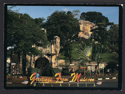
2nd ~ A Famosa Castle built in 1511 by the Portuguese, damaged during the Dutch invasion ~
 Sent 16-09-2009, Cancellation on 17-09-2009
Thanks for Jasmine Chin (Johor Bahru), sent to Bangkok Thailand

Kuala Lumpur Railway Station (Malay: Stesen Keretapi Kuala Lumpur) is a train station located in Kuala Lumpur, Malaysia. Completed in 1910 to replace an older station on the same site, the station was Kuala Lumpur's railway hub in the city for the Federated Malays States Railway and Malayan Railway (Malay: Keretapi Tanah Melayu), before Kuala Lumpur Sentral assumed much of its role in 2001. The station is notable for it architecture, adopting a mixture of Eastern and Western designs.
The station is located along a road named Jalan Sultan Hishamuddin, previously known as Victory Avenue, which in turn was part of Damansara Road. The station is located closely to the similarly designed Railway Administration Building, as well as the National Mosque and Dayabumi Complex. The Pasar Seni LRT station is located 400 metres away, across the Klang River.

Sent from Malacca to Negeri Sembilan

~ A Famosa Castle built in 1511 by the Portuguese, damaged during the Dutch invasion ~
  Sent 06-03-2010, Cancellation on 08-03-2010, Received 11-03-2010

http://711collection.blogspot.com/

A Famosa (Malay: Kota A Famosa), or "The Famous" in Portuguese, is a fortress located in Malacca, Malaysia. It is among the oldest surviving European architectural remains in Asia. The Porta de Santiago, a small gate house, is the only remaining part of the fortress still standing.
The name is often mispronounced as /ei/ Famosa, even among Malaysians (as though the Portuguese definite article "a" were the letter "A" in the English alphabet). A more accurate pronunciation would be /ɑ/ Famosa (approximating 'ah').

In 1511, a Portuguese fleet arrived under the command of Afonso de Albuquerque. His forces attacked and successfully defeated the armies of the Malacca Sultanate. Moving quickly to consolidate his gains, Albuquerque had the fortress built around a natural hill near the sea.Albuquerque believed that Malacca  would become an important port linking Portugal to the spice trade from China. At this time other Portuguese  were establishing outposts in such places as Macau, China and Goa, India in order to create a string of friendly ports for ships heading to China and returning home to Portugal.

The fortress once consisted of long ramparts and four major towers. One was a four-story keep, while the others held an ammunition storage room, the residence of the captain, and an officers' quarters. Most of the village clustered in town houses inside the fortress walls. As Malacca's population expanded it outgrew the original fort and extensions were added around 1586. The fort changed hands in 1641 when the Dutch successfully drove the Postuguese out of Malacca. The Dutch renovated the gate in 1670, which explains the logo "ANNO 1670" inscribed on the gate's arch. Above the arch is a bas-relief logo of the Dutch East India Company.
The fortress changed hands again in the early 19th century when the Dutch handed it over to the British to prevent it from falling into the hands of Napoleon's expansionist France. The English were wary of maintaining the fortification and ordered its destruction in 1806. The fort was almost totally demolished but for the timely intervention of Sir Stamford Raffles, the founder of Singapore, who happened to visit Malacca in 1810. Because of his passion for history, this small gate was spared from destruction.

Thursday, March 18, 2010

Milan - Czech Republic


 ~ Olomouc (UNESCO) ~
Sent 06-10-2009
Thanks for Milan!!

Olomouc (Czech pronunciation: [ˈolomou̯ts]; local Haná dialect Olomóc or Holomóc, German Olmütz, Polish Ołomuniec, Latin Eburum or Olomucium) is a city in Moravia, in the east of the Czech Republic. The city is located on the Morava river and is the ecclesiastical metropolis of Moravia.
Olomouc contains several large squares, the chief of which is adorned with Holy Trinity Column, a UNESCO World Heritage Site. The column is 115 ft (35 m) high and was built in 1716–1754.