Friday, April 30, 2010

Jasmine Chin - Malaysia


1st ~ Kuala Lumpur Railway Station ~
 Sent 01-10-2009, Cancellation on 02-10-2009
2nd ~ A Famosa Castle built in 1511 by the Portuguese, damaged during the Dutch invasion ~
 Sent 16-09-2009, Cancellation on 17-09-2009
Thanks for Jasmine Chin (Johor Bahru), sent to Bangkok Thailand

Kuala Lumpur Railway Station (Malay: Stesen Keretapi Kuala Lumpur) is a train station located in Kuala Lumpur, Malaysia. Completed in 1910 to replace an older station on the same site, the station was Kuala Lumpur's railway hub in the city for the Federated Malays States Railway and Malayan Railway (Malay: Keretapi Tanah Melayu), before Kuala Lumpur Sentral assumed much of its role in 2001. The station is notable for it architecture, adopting a mixture of Eastern and Western designs.
The station is located along a road named Jalan Sultan Hishamuddin, previously known as Victory Avenue, which in turn was part of Damansara Road. The station is located closely to the similarly designed Railway Administration Building, as well as the National Mosque and Dayabumi Complex. The Pasar Seni LRT station is located 400 metres away, across the Klang River.

KKKhor - Malaysia


1st ~ Ipoh, Capital of Perak ~
 Sent 12-10-2009, Cancellation on 13-10-2009
Thanks for KKKhor (Ipoh Perak) , sent to Bangkok Thailand

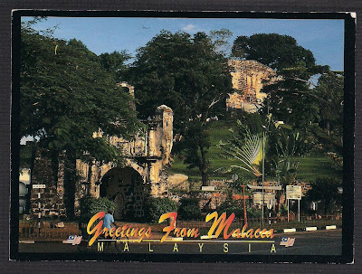
Sent from Malacca to Negeri Sembilan

~ A Famosa Castle built in 1511 by the Portuguese, damaged during the Dutch invasion ~
  Sent 06-03-2010, Cancellation on 08-03-2010, Received 11-03-2010

http://711collection.blogspot.com/

A Famosa (Malay: Kota A Famosa), or "The Famous" in Portuguese, is a fortress located in Malacca, Malaysia. It is among the oldest surviving European architectural remains in Asia. The Porta de Santiago, a small gate house, is the only remaining part of the fortress still standing.
The name is often mispronounced as /ei/ Famosa, even among Malaysians (as though the Portuguese definite article "a" were the letter "A" in the English alphabet). A more accurate pronunciation would be /ɑ/ Famosa (approximating 'ah').

In 1511, a Portuguese fleet arrived under the command of Afonso de Albuquerque. His forces attacked and successfully defeated the armies of the Malacca Sultanate. Moving quickly to consolidate his gains, Albuquerque had the fortress built around a natural hill near the sea.Albuquerque believed that Malacca  would become an important port linking Portugal to the spice trade from China. At this time other Portuguese  were establishing outposts in such places as Macau, China and Goa, India in order to create a string of friendly ports for ships heading to China and returning home to Portugal.

The fortress once consisted of long ramparts and four major towers. One was a four-story keep, while the others held an ammunition storage room, the residence of the captain, and an officers' quarters. Most of the village clustered in town houses inside the fortress walls. As Malacca's population expanded it outgrew the original fort and extensions were added around 1586. The fort changed hands in 1641 when the Dutch successfully drove the Postuguese out of Malacca. The Dutch renovated the gate in 1670, which explains the logo "ANNO 1670" inscribed on the gate's arch. Above the arch is a bas-relief logo of the Dutch East India Company.
The fortress changed hands again in the early 19th century when the Dutch handed it over to the British to prevent it from falling into the hands of Napoleon's expansionist France. The English were wary of maintaining the fortification and ordered its destruction in 1806. The fort was almost totally demolished but for the timely intervention of Sir Stamford Raffles, the founder of Singapore, who happened to visit Malacca in 1810. Because of his passion for history, this small gate was spared from destruction.

Carol L. Ligda-Wong - USA

1st ~ Mackinac Bridge, sent out during the Mackanic Bridge Walk, with Zodiac Cow stamp ~
Sent 07-09-2009
2nd ~ Mackinac Bridge, Total length 5miles ~
Sent 07-09-2009,  
special cancellation "Mackanic Bridge Walk Station", Machine Cancellation

The Mackinac Bridge, is asuspension bridge spanning the Straits of Mackinac to connect the non-contiguous Upper and Lower peninsulas of the U.S.state of Michigan. Envisioned since the 1880s, the bridge was completed only after many decades of struggles to begin construction. Designed by engineer David B. Steinman, the bridge (familiarly known as "Big Mac" and "Mighty Mac") connects the city of St.Ignance on the north end with the village of Mackinaw City on the south. It is the longest suspension bridge between anchorages in the Western hemisphere.
The bridge opened on November 1, 1957, ending decades of the two peninsulas being solely linked by ferries. At 8,614 feet (2,626 m), the Mackinac Bridge is the longest suspension bridge with two towers between anchorages in the Western Hemisphere.The length of the bridge's main span is 3,800 feet (1,158 m), which makes it the third-longest suspension span in the United States and twelfth longest worldwide. 
Total length 26,372 feet (8,038 m)
Width 68.6 feet (20.9 m) (total width)
Height 522 feet (159 m)

Bridge Walk
The Mackinac Bridge Walk has been held each year since 1958, when it was led by Governor G.Mennen Williams. The first walk was held during the Bridge's Dedication Ceremony held in late June, and has been held on Labor Day since 1959. Thousands of people, traditionally led by the Governor of Michigan, cross the five-mile (8 km) span on foot from St. Ignace to Mackinaw City since 1964. Before that, people walked the Bridge from Mackinaw City to St. Ignace.

Paul Choong - Taiwan


Sent 01-10-2009, Cancellation on 02-10-2009
~ The Cable Bridge of the Kao-Ping stream 高屏溪斜张桥 ~ 

Wednesday, April 28, 2010

Marilyn Monroe PostCard


anyone could help me to translate this Japanese Language? ... I really interesting to know what's the content writting.

Thursday, April 8, 2010

Johan - Belgium


~ Antwerpen, Belgium ~
Sent 17-09-2009
Thanks for Johan Ockerman!!
http://johanpostcards.blogspot.com/
Antwerp is a city and municipality in Belgium and the capital of the Antwerp province in Flanders, one of Belgium's three regions. Antwerp's total population is 472,071 (as of 1 January 2008) and its total area is 204.51 km2 (78.96 sq mi), giving a population density of 2,308 inhabitants per km2. The metropolitan area, including the outer commuter zone, covers an area of 1,449 km2 (559 sq mi) with a total of 1,190,769 inhabitants as of 1 January 2008. The nickname of inhabitants of Antwerp is Sinjoren, after the Spanish word señor, which means 'mister' or 'gent'.
Antwerp has long been an important city in the nations of the Benelux both economically and culturally, especially before the Spanish Fury of the Dutch Revolt. It is located on the right bank of the river Scheldt, which is linked to the North Sea by the estuary Westerschelde.

Posting at Kuantan, Malaysia


~ The Sultan Abdul Samad Building in Kuala Lumpur, Paku-Pakis stamp 2010 ~

Sent 1st April 2010 (April Fool Day),
Cancellation on 1st April 2010

The Sultan Abdul Samad Building is located in front of the Dataran Merdeka - literally the Independence Square - and the Royal Selangor Club, by Jalan Tunku Abdul Rahman in Kuala Lumpur, Malaysia. The structure takes its name from Sultan Abdul Samad, the reigning sultan of Selangor at the time when construction began.

History

It was designed by A.C. Norman and built in 1894-1897 to house several important government departments during the British administration. A.C. Norman spent time in Africa and saw Muslim mosques in India which led him to use Moorish architecture in the building's design. In 1945, when World War II ended, Britain resumed control again, but Malaya's independence movement had matured and organized itself in an alliance under Tunku Abdul Rahman. When the British flag was finally lowered in Kuala Lumpur's Merdeka Square in 1957, Tunku became the first prime minister of Malaya.
In front of the building is the Dataran Merdeka (or Merdeka Square). It was here, the Union Jack flag was lowered and the Malayan Flag  hoisted for the first time at midnight on August 31, 1957. The Dataran Merdeka was officially opened on January 1, 1990, in conjunction with Visit Malaysia Year 1990.
The Merdeka Square symbolized British sovereignty as it was a cricket ground for the colonial administrators and fronted the Royal Selangor Club, Malaya's most exclusive whites-only club.
In 1961, Abdul Rahman mooted the idea of the establishment of "Malaysia", which would consist of Singapore, Sabah, Sarawak and Brunei, all of which had still been British colonies. The reasoning behind this was that it would allow the federal government to control and combat communist activities, especially in Singapore. It was also feared that if Singapore achieved independence, it would become a base for Chinese chauvinists to threaten Malayan sovereignty. To balance out the ethnic composition of the new nation, the other states, whose Malay and indigenous populations would cancel out the Chinese majority in Singapore, were also included.
A 95-meter flagpole, one of the tallest in the world, marks that spot with a flat, round black marble plaque. It is located at the southern end of the square.
To mark the occasion on the morning of Merdeka Day, Thousands of spectators converge on the city to watch the colourful parade along the streets of the city and performances held at the Merdeka Square. Each state will be represented, as are the many ethnic groups that comprise multiracial Malaysia. The National Flag will be flown throughout the country, at office buildings, private homes and on vehicles. State shows, competitions and exhibitions will also be held in all states. This year, Malaysia celebrates her 53rd birthday.
During state occasions, coloured lights twinkle in the arches. The section of Jalan Raja is closed in order for the people to enjoy the night scenery of the area.

IT-79065, Irene - Italy


~ Dolomite, Italy ~ (IT-79065)    
Sent 19-03-2010
Cancellation on 20-03-2010
Thanks for Irene!!
(I'm glad that first time received Italy postcard)

The Dolomites are a section of the Alps. They are located for the most part in the province of Belluno, the rest in the provinces of Bolzano-Bozen and Trento (all in north-eastern Italy). Conventionally they extend from the Adige river in the west to the Piave valley (Pieve di Cadore) in the east. The northern and southern borders are defined by the Puster Valley and the Sugana Valley (Val Sugana). But the Dolomites spread also over the Piave river (Dolomiti d'Oltrepiave) to the east; and far away over the Adige river to the west is the Brenta Group (Western Dolomites); there is also another smaller group called Piccole Dolomiti (Small Dolomites) located between the Provinces of Trento, Verona and Vicenza.
One national park and many other regional parks are located in the Dolomites. In August 2009, the Dolomites has been declared natural heritage of the UNESCO

NL-312952, Zara & Stefan - Netherland


~ Hoorn, Netherland ~ (NL-312952)    
Sent 19-03-2010
Thanks for Zara (6years Old) & Zara's Father Stefan!!